Geography of England
|
||
| Continent | Europe | |
| Subregion | Northern Europe Great Britain |
|
| Area - Total - Land (%) - Water (%) |
130,395 km2 (50,346 sq mi) 98% 2% |
|
| Coastline | 3,200 km (1,988 mi) | |
| Land borders | Scotland 96 km (60 mi) Wales 257 km (160 mi) |
|
| Highest point | Scafell Pike 978 m (3,209 ft) |
|
| Lowest point | The Fens, -4 m | |
| Longest river | River Severn (shared with Wales) 354 km (220 mi) Longest river entirely within England is the River Thames 346 km (215 mi) |
|
| Largest inland body of water | Windermere 14.73 km2 (5.69 sq mi) |
|
| Climate: | Oceanic "British" climate with small areas of Subarctic climate |
|
| Terrain: | low mountains, hills, forests, lowlands, urban | |
| Natural resources | iron, zinc, potash, silica sand,fish, timber, wildlife, petroleum, natural gas, hydropower, wind power, lead, tin, copper, china clay, arable land, coal | |
| Natural hazards | European windstorms, floods, few and small Tornadoes | |
| Environmental issues | climate change, rising sea levels, renewable energy, waste disposal,water pollution, population density | |
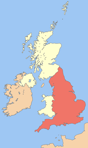
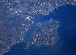
England comprises the central and southern two-thirds of the island of Great Britain, in addition to a number of small islands of which the largest is the Isle of Wight. England is bordered to the north by Scotland and to the west by Wales. It is closer to continental Europe than any other part of mainland Britain, divided from France only by a 24-statute mile (52 km or 28.1 nmi)[1] sea gap. The Channel Tunnel, near Folkestone, directly links England to mainland Europe. The English/French border is halfway along the tunnel.[2]
Much of England consists of rolling hills, but it is generally more mountainous in the north with a chain of mountains, the Pennines, dividing east and west. Other hilly areas in the north and Midlands are the Lake District, the North York Moors, and the Peak District. The approximate dividing line between terrain types is often indicated by the Tees-Exe line. To the south of that line, there are larger areas of flatter land, including East Anglia and the Fens, although hilly areas include the Cotswolds, the Chilterns, and the North and South Downs.
The largest natural harbour in England is at Poole, on the south-central coast. Some regard it as the second largest harbour in the world, after Sydney, Australia, although this fact is disputed (see harbours for a list of other large natural harbours).
Contents
|
Climate
England has a temperate climate, with plentiful rainfall all year round, although the seasons are quite variable in temperature. However, temperatures rarely fall below −5 °C (23 °F) or rise above 30 °C (86 °F). The prevailing wind is from the south-west, bringing mild and wet weather to England regularly from the Atlantic Ocean. It is driest in the east and warmest in the south, which is closest to the European mainland. Snowfall can occur in winter and early spring, although it is not that common away from high ground. England has warmer maximum and minimum temperatures throughout the year than the other countries of the UK, though Wales has milder minimums from November to February, and Northern Ireland has warmer maximums from December to February. England is also sunnier throughout the year, but unlike Wales, Northern Ireland and Scotland, the sunniest month is July, totalling 192.8 hours.
The highest temperature recorded in England is 38.5 °C (101.3 °F) on 10 August 2003 at Brogdale, near Faversham, in Kent.[3] The lowest temperature recorded in England is −26.1 °C (−15.0 °F) on 10 January 1982 at Edgmond, near Shropshire. The climate of south-west England is rather distinct and somewhat milder than the rest of England, forming its own separate climate. Crops, flowers and plants can be grown much earlier in the South West than in the rest of England or the UK.
| England 1971-2000[4] | ||||||||||||||||||||||||||||||||||||||||||||||||||||||||||||
|---|---|---|---|---|---|---|---|---|---|---|---|---|---|---|---|---|---|---|---|---|---|---|---|---|---|---|---|---|---|---|---|---|---|---|---|---|---|---|---|---|---|---|---|---|---|---|---|---|---|---|---|---|---|---|---|---|---|---|---|---|
| Climate chart () | ||||||||||||||||||||||||||||||||||||||||||||||||||||||||||||
|
||||||||||||||||||||||||||||||||||||||||||||||||||||||||||||
|
||||||||||||||||||||||||||||||||||||||||||||||||||||||||||||
| England Climate Averages | ||||||||||||||
|---|---|---|---|---|---|---|---|---|---|---|---|---|---|---|
| Month | Jan | Feb | Mar | Apr | May | Jun | Jul | Aug | Sep | Oct | Nov | Dec | Year | |
| Average maximum temperature °C (°F) | 6.6 (43.9) |
6.9 (44.4) |
9.3 (48.7) |
11.7 (53.1) |
15.4 (59.7) |
18.1 (64.6) |
20.6 (69.1) |
20.5 (68.9) |
17.5 (63.5) |
13.6 (56.5) |
9.5 (49.1) |
7.4 (45.3) |
13.1 (55.6) |
|
| Average minimum temperature °C (°F) | 1.1 (34.0) |
1.0 (33.8) |
2.4 (36.3) |
3.6 (38.5) |
6.3 (43.3) |
9.1 (48.4) |
11.4 (52.5) |
11.2 (52.2) |
9.3 (48.7) |
6.6 (43.1) |
3.5 (38.3) |
2.0 (35.6) |
5.6 (42.1) |
|
| Sunshine hours |
50.5 | 67.7 | 102.5 | 145.2 | 189.9 | 179.4 | 192.8 | 184.1 | 135.0 | 101.3 | 65.2 | 43.9 | 1457.4 | |
| Rainfall mm (inches) |
84.2 (3.3) |
60.1 (2.4) |
66.5 (2.6) |
56.8 (2.2) |
55.9 (2.2) |
62.9 (2.5) |
54.1 (2.1) |
66.7 (2.6) |
73.3 (2.9) |
83.6 (3.3) |
83.5 (3.3) |
90.4 (3.6) |
838.0 (33.0) |
|
| Rainfall ≥ 1 mm days |
13.4 | 10.4 | 12.1 | 10.1 | 9.8 | 9.8 | 8.5 | 9.4 | 10.2 | 11.8 | 12.5 | 13.1 | 131.2 | |
| Source: Met Office[4] (1971–2000 averages) | ||||||||||||||
Geology
The Geology of England is mainly sedimentary. The youngest rocks are in the south east, progressing in age in a north westerly direction. The Tees-Exe line marks the division between younger, softer and low-lying rocks in the south east and older, harder, and generally a higher relief in north west of the line. The geology of England is recognisable in the landscape of its counties, for instance Cumbria, Kent and Norfolk all have very distinct and very different looks from each other. The geology of Northern England and Western England tends to be somewhat closer to that of its near neighbours, Wales and Scotland, with the geology of Southern England and Eastern England being more aligned with that found across the North Sea and English Channel in Northern France, Belgium and the Netherlands.
Geological features:
- Cheddar Gorge - the largest gorge in Great Britain
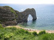
- Jurassic Coast - a UNESCO World Heritage Site
- Salisbury Plain
- Tees-Exe line
- Whin Sill
- London Basin
- Hampshire Basin
- London-Brabant Massif
- Dartmoor - one of a series of Moors in the South West of England developing Tors on a granitic batholith
- Lizard Complex - an ancient piece of oceanic crust, onshore (i.e. an Ophiolite).
Geological resources:
- Coal
- North Sea oil
- Sand and Gravel
- China Clay
- Copper and Tin
- Stone
- North Sea gas
and less abundantly,
- Geothermal energy
- Onshore oil
Major towns and cities
London is by far the largest urban area in England and one of the largest and busiest cities in the world. Other cities, mainly in central and northern England, are of substantial size and influence. The list of England's largest cities or urban areas is open to debate because, although the normal meaning of city is "a continuously built-up urban area", this can be hard to define, particularly because administrative areas in England often do not correspond with the limits of urban development, and many towns and cities have, over the centuries, grown to form complex urban agglomerations.[5][6] For the official definition of a UK (and therefore English) city, see City status in the United Kingdom.
According to the ONS urban area populations for continuous built-up areas, these are the 15 largest conurbations (population figures from the 2001 census):
| Rank | Urban Area[7] | Population
(2001 Census) |
Localities | Major localities |
|---|---|---|---|---|
| 1 | Greater London Urban Area | 8,278,251 | 67 | Croydon, Barnet, Ealing, Bromley |
| 2 | West Midlands Urban Area | 2,284,093 | 22 | Birmingham, Wolverhampton, Dudley, Walsall |
| 3 | Greater Manchester Urban Area | 2,240,230 | 57 | Manchester, Salford, Bolton, Stockport, Oldham |
| 4 | West Yorkshire Urban Area | 1,499,465 | 26 | Leeds, Bradford, Huddersfield, Wakefield |
| 5 | Tyneside | 879,996 | 25 | Newcastle upon Tyne, North Shields, South Shields, Gateshead, Jarrow |
| 6 | Liverpool Urban Area | 816,216 | 8 | Liverpool, St Helens, Bootle, Huyton-with-Roby |
| 7 | Nottingham Urban Area | 666,358 | 15 | Nottingham, Beeston and Stapleford, Carlton, Long Eaton |
| 8 | Sheffield Urban Area | 640,720 | 7 | Sheffield, Rotherham, Chapeltown, Mosborough/Highlane |
| 9 | Bristol Urban Area | 551,066 | 7 | Bristol, Kingswood, Mangotsfield, Stoke Gifford |
| 10 | Brighton/Worthing/Littlehampton | 461,181 | 10 | Brighton, Worthing, Hove, Littlehampton, Shoreham, Lancing |
| 11 | Portsmouth Urban Area | 442,252 | 7 | Portsmouth, Gosport, Waterlooville, Fareham |
| 12 | Leicester Urban Area | 441,213 | 12 | Leicester, Wigston, Oadby, Birstall |
| 13 | Bournemouth Urban Area | 383,713 | 5 | Bournemouth, Poole, Christchurch, New Milton |
| 14 | Reading/Wokingham Urban Area | 369,804 | 5 | Reading, Bracknell, Wokingham, Crowthorne |
| 15 | Teesside | 365,323 | 7 | Middlesbrough, Stockton-on-Tees, Redcar, Billingham |
The largest cities in England are as follows (in alphabetical order):
- Birmingham
- Bradford
- Bristol
- Coventry
- Derby
- Kingston upon Hull
- Leeds
- Leicester
- Liverpool
- London
- Manchester
- Middlesbrough
- Newcastle upon Tyne
- Norwich
- Nottingham
- Oxford
- Peterborough
- Plymouth
- Portsmouth
- Sheffield
- Southampton
- Stoke-on-Trent
- Wolverhampton
Physical geography
Extreme points
The extreme points of England are:
England (mainland)
- Northernmost point – Marshall Meadows Bay, Northumberland at
- Northernmost settlement – Marshall Meadows, Northumberland at
- Southernmost point – Lizard Point, Cornwall at
- Southernmost settlement – Lizard, Cornwall at
- Westernmost point – Dr Syntax's Head, Land's End, Cornwall at
- Westernmost settlement – Sennen Cove, Cornwall at
- Easternmost point – Lowestoft Ness, Suffolk at
- Easternmost settlement – Lowestoft, Suffolk at
England (including islands)
- Northernmost point – Marshall Meadows Bay, Northumberland at
- Northernmost settlement – Marshall Meadows, Northumberland at
- Southernmost point – Western Rocks, Isles of Scilly at
- Southernmost settlement – St Agnes, Isles of Scilly at
- Westernmost point – Crim Rocks, Isles of Scilly at
- Westernmost settlement – St Agnes, Isles of Scilly at
- Easternmost point – Lowestoft Ness, Suffolk at
- Easternmost settlement – Lowestoft, Suffolk at
Topography, mountains and hills
England is generally lower and flatter than the rest of the UK, but has two main divisions in its form - the lowland areas of the south, east and Midlands and the more rugged and upland areas of the north and west. East Anglia is the lowest area of England, having no high hills or mountains and hosting an area of the Fens, the lowest area of England. The highest area of England is the North West which contains England's highest hills and mountains, including its highest - Scafell Pike.
In England a mountain is generally classed as being taller than 600m, so most fall in Northern England. Some hill and mountain chains in England are:
- Cumbrian Mountains - the highest mountains in England, containing Scafell Pike
- The Cheviots - some refer to these as an extension of the Southern Uplands in Scotland.
- The Pennines which characterise much of Northern England and are often dubbed "the backbone of England".
- North York Moors - a area of hills and moorlands beside the North Sea.
- Exmoor - uplands beside the Bristol Channel
- Dartmoor - an area of uplands in the heart of Devon.
- The Cotswolds - a quintessentially and stereotypical English rural area
- Chilterns - a collection of low hills.
- South Downs - low hills close to the English Channel which form the white cliffs of the English South Coast.
Islands
Besides the Island of Great Britain which forms the bulk territory of England, Scotland and Wales, England also has a number of other islands. The Isle of Man and Channel Islands although sometimes treated as part of England for governmental purposes do not form part of England itself. Although are often represented in the English regions of North West England (Isle of Man and South West England (Channel Islands, these islands are not treated as part of England here.
Here are the main English islands by size and population, a full list can be found at List of islands of England.
List of Largest islands in England
| Rank | Island | Area (sq mi) | Area (km²) |
|---|---|---|---|
| 1 | Isle of Wight | 147.09 | 380.99 |
| 2 | Isle of Sheppey | 36.31 | 94.04 |
| 3 | Hayling Island | 10.36 | 26.84 |
| 4 | Foulness Island | 10.09 | 26.84 |
| 5 | Portsea Island | 9.36 | 24.25 |
| 6 | Canvey Island | 7.12 | 18.45 |
| 7 | Mersea Island | 6.96 | 18.04 |
| 8 | Walney Island | 5.01 | 12.99 |
| 9 | Portland | 4.44 | 11.5 |
| 10 | Wallasea Island | 4.11 | 10.65 |
English islands by population
| Rank | Island | Population (2001 UK census) |
|---|---|---|
| 1 | Portsea Island | 147,088 |
| 2 | Isle of Wight | 132,731 |
| 3 | Isle of Sheppey | 37,852 |
| 4 | Canvey Island | 37,473 |
| 5 | Hayling Island | 16,887 |
| 6 | Portland | 12,800 |
| 7 | Walney Island | 11,391 |
| 8 | Mersea Island | about 7,200 |
| 9 | Barrow Island | 2,606 |
| 10 | St Mary's | 1,668 |
| 11 | Thorney Island | 1,079 |
| 12 | Foulness | 212 |
| 13 | Tresco | 180 |
| 14 | Lindisfarne | 162 |
| 15 | St Martins | 142 |
| 16 | Roa Island | about 100 |
| 17 | Bryher | 92 |
| 18 | St Agnes | 73 |
| 19 | Lundy | about 28 |
Rivers
The longest river in England is the River Severn which has its source in Wales, forms much of the Anglo-Welsh border and flows into the Bristol Channel. The longest river entirely within England is the River Thames which flows through the English and British capital, London. The Vale of York and The Fens host many of England's larger rivers.
Coastline
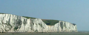
England has 3200 km of coastline, much smaller than the deeply indented Scottish coastline, but still a considerable length. The English coastline varies a great deal by seas and regions it borders. The North Sea coast of England is mainly flat and sandy with many dunes and is reminiscent of coastlines across the sea from it in the Netherlands. The English North Sea coast is an important area of bird life and is a habitat for many shore and wading birds, with The Wash being amongst one of the most important areas for bird watching. Along the English Channel, the South Coast builds up into steep, white cliffs which are often seen as an iconic symbol of England and Britain.
The South coast continues to the Isle of Wight, but eventually gives way to the Jurassic Coast of Dorset, a coastline rich in beauty, history and fossils.
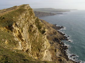
Into Devon and Cornwall the coastline becomes more rocky and steep, with numerous cliffs and tiny fishing villages along the coastline, Cornwall is best noted for this. This stretch of coastline stretches from Devon all the way to Land's End in Cornwall, the westernmost part of mainland England. The coastline of Devon and Cornwall has similarities to that of Brittany in France directly opposite.
Following the coastline northwards the coast remains much the same as in south Devon and Cornwall but is besides the Celtic Sea until it eventually reaches the Bristol Channel, an important shipping and docking area.
The English coastline re-emerges again in North West England. The coastline here is similar to the North Sea coast in that it is mainly flat and sandy, with the only notable cliffs along this stretch of coast being at St Bee's Head in Cumbria. The English Irish Sea coast is an important area of estuaries and bird life, with The Wirral being a peninsular bounded by two rivers, the River Dee and most importantly the River Mersey. Liverpool and Merseyside are important areas of population and industry along this coast, with tourist resorts of Southport and Blackpool being further to the north. The English Irish Sea coast hosts two important geographic areas in Morecambe Bay, a large and somewhat dangerous bay, but rich in aquatic life and the Furness and Walney Island areas. Further north into Cumbria the controversial Sellafield Nuclear Power Station lies along this coast. The English section of the Irish Sea coast ends at the border with Scotland in the Solway Firth.
Seas bordering England are:
Largest lakes and reservoirs
Although the largest nation within the UK, England is relatively absent of large lakes, with many of its former wetlands being drained throughout the Middle Ages. Most of its largest lakes lie within the aptly naimed Lake District in Cumbria, Northern England.
Here is a small list of England's largest lakes:
| Lake | Area (sq mi) | |
|---|---|---|
| 1 | Windermere | 5.69 |
| 2 | Kielder Reservoir | 3.86 |
| 3 | Ullswater | 3.44 |
| 4 | Bassenthwaite Lake | 2.06 |
| 5 | Derwent Water | 2.06 |
Land use
The total land area of England is 129,720 km squared. Crops and fallow land accounts for 30 per cent of the land area, grasses and rough grazing 36 per cent, other agricultural land 5 per cent, forest and woodland 8 per cent, and urban development 21 per cent.[8]
Neighbouring countries
England has two land borders, one with Scotland which runs for 96 km and it's longest with Wales which runs for 257 km. It is bordered across the Irish Sea by Ireland and the Isle of Man to the west, and across the North Sea by Denmark, Germany and the Netherlands and across the English Channel to the south by France and the Channel Islands.
Economic geography
England boasts one of the largest economies in Europe and indeed the world, with an average GDP per capita of £22,907. England's economy is usually regarded as a mixed market economy, it has adopted many free market principles in contrast to the Rhine Capitalism of Europe, yet maintains an advanced social welfare infrastructure. The currency in England is the pound sterling, also known as the GBP and England prints its own banknotes which are also circulated in Wales. The economy of England is the largest part of the United Kingdom's economy.
Regional differences:
.png)
The strength of the English economy varies from region to region. GDP, and GDP per capita is highest inLondon. Generally the Northern and Western areas of England are the poorest, with the Southern and Eastern areas being the richest. The following table shows the GDP (2004) per capita of England as a whole and each of the nine regions.
| Rank | Place | GDP per capita in Euros |
|---|---|---|
| England | 26 904 | |
| 1. | London | 44 401 |
| 2. | South East | 31 300 |
| 3. | East of England | 27 778 |
| 4. | South West | 27 348 |
| 5. | East Midlands | 26 683 |
| 6. | West Midlands | 25 931 |
| 7. | North West | 25 396 |
| 8. | Yorkshire and the Humber | 25 300 |
| 9. | North East | 22 886 |
Two of the 10 economically strongest areas in the European Union are in England. Inner London is number 1 with a €71 338 GDP per capita (303% above EU average);Berkshire, Buckinghamshire & Oxfordshire is number 7 with a €40 937 GDP per capita (174% above EU average).
Political Geography
England, formerly a kingdom and independent country united with Scotland to form what would eventually become the UK (Wales was treated as part of England at that time).
England is in a unique and controversial position of being a political entity within the UK and yet having no self-governance. England is represented by MPs in the British Parliament and matters relating only to England are also dealt with by the UK parliament. England is divided into a number of regions which also send representatives to the European Parliament.
England includes islands such as the Isle of Wight, Walney and Lundy, but excludes the Crown Dependencies of the Isle of Man and Channel Islands.
See also
- North-South divide in England
- Geography of the United Kingdom
- Geography of Scotland
- Geography of Wales
- Geology of England
- Climate of England
- List of islands in England
- List of rivers in England
- List of lakes in England
- Economy of England
- Lake District
- Pennines
- Northern England
- Southern England
- North Sea
References
- ↑ Eurotunnel.com – UK History
- ↑ "TravelBritain – Kent". http://www.travelbritain.com/England/Kent/index.html.
- ↑ Temperature record changes hands BBC News, 30 September 2003. Retrieved 12 September 2006.
- ↑ 4.0 4.1 "England 1971–2000 averages". Met Office. 2001. http://www.metoffice.gov.uk/climate/uk/averages/19712000/areal/england.html. Retrieved 2007-08-14.
- ↑ "Religious centres recover city status", The Guardian, 8 July 1994.
- ↑ Patrick O'Leary, "Derby's long road to city status", The Times, 29 July 1977, p.14
- ↑ Pointer, Graham (2005). "The UK’s major urban areas". Focus on People and Migration. Office for National Statistics. http://www.statistics.gov.uk/downloads/theme_compendia/fom2005/03_FOPM_UrbanAreas.pdf. Retrieved 2009-06-06.
- ↑ UK 2005. The Official Yearbook of the United Kingdom of Great Britain and Northern Ireland.. London: The Stationery Office. 2004. pp. 279. ISBN 0 11 621738 3.
|
||||||||||||||||||||||||||
|
||||||||||||||
|
||||||||||||||